
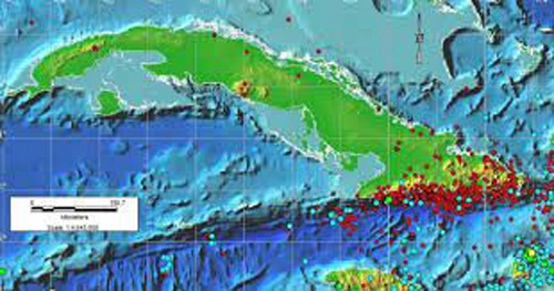
Cuba has its first tsunami hazard map, a tool that strengthens the disaster risk reduction scheme in the archipelago, especially in the coasts of Guantanamo and Holguin, based on a research by the National Seismological Research Center (Cenais for its Spanish acronym).
Map, tsunami hazard, Cuba
According to Cenais, the localities most exposed to this type of event are Maisí, Baracoa (both in Guantanmo) and Moa (Holguin), located in the northeastern end of the country, and the beaches on the northern coast of the country’s eastern half, among them Cayo Saetía, Guardalavaca (both in Holguin) and Cayo Coco in Ciego de Avila.
The presentation of the new map was made in the context of the XI International Congress on Disasters, which is in session until Friday at the Convention Palace in Havana, together with the VII International Conference of Firefighters.
The experts prepared the map with high scientific rigor and used data from all the faults with the potential to generate earthquakes capable of producing tsunamis in our geographic area.
In the Greater Antilles there is no high danger of occurrence of this type of event, but it is important to bear in mind that the phenomenon was recorded in 1882 and 1946 in the segment of the northern fault of Haiti and the Dominican Republic.
To the south of Cuba there are no seismotectonic conditions for the occurrence of earthquakes triggering tsunamis, which is consistent with the fact that none of the strong earthquakes occurred in the Oriente fault, and much less in the Caribbean, generated any, details Prensa Latina.
In addition to the TsunAWI software, the scientists of the National Center for Seismological Research took into account the modeling of other scenarios, located in the so-called Caribbean basin, related to different plate boundaries considered in different studies of the Intergovernmental Oceanographic Commission of the Caribbean.
The map, experts assure, shows very reliable results in its application.
With information of Juventud Rebelde and Trabajadores / Translated by Radio Angulo
- Modern Technology Added to Community Polyclinic in Holguin - 29 de July de 2026
- National Assembly Holds Seventh Ordinary Session - 29 de July de 2026
- Cuban Foreign Ministry Rejects Announcement by Colombian President - 29 de July de 2026